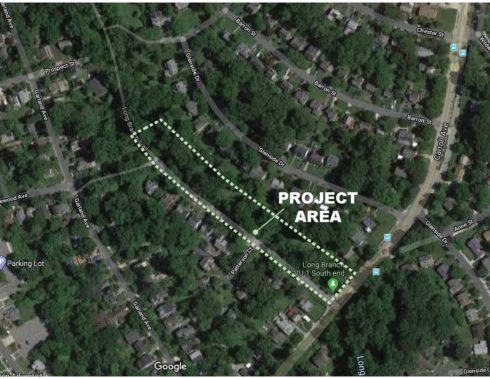
Click on the image to view larger.
Project Description
This project will evaluate the proposed construction of a hard surface trail extension from the end of the existing Long Branch Trail to Carroll Avenue. The project area is located in the Long Branch Stream Valley Park in Stream Valley Unit #1, near the intersection of Long Branch Parkway and Carroll Avenue in Takoma Park. The Long Branch Trail currently ends at the dead-end of Long Branch Parkway. Currently, there is a people’s choice trail (unsanctioned trail) that parallels the Long Branch Stream Valley Park on the northeast side of the stream to Carroll Avenue. The majority of the potential extension alignment is on parkland, while some small areas may be within Montgomery County Department of Transportation (MCDOT) and/or SHA right-of-way (pending an approved alignment).
The project location contains some environmentally sensitive areas, including some mature trees and forested areas, groundwater seeps, localized erosion features, and abundant non-native/invasive plants in some areas. There are excellent opportunities in this area for incorporating environmental enhancements, including tree replacement, removal of non-native/invasive (NNI) plants, floodplain, and stream buffer habitat enhancement, and restoration replanting.
Background
This project is one of several projects planned in the Long Branch Stream Valley Park corridor with a goal of creating a continuous and updated Long Branch Trail from Piney Branch Road to Carroll Avenue. This project will help improve trail connectivity in the greater Long Branch area.
The existing people’s choice trail to Carroll Avenue shows significant use and there are maintenance concerns with the area. There is a history of tree loss in this area, the general area has poor drainage, and the foot trail has widened over time leading to loss of vegetation with localized erosion. Therefore, the second goal of this project is to enhance pedestrian and cyclist safety while also enhancing park resources by incorporating restorative plantings, NNI removal, drainage improvements, and floodplain habitat enhancements.
Status/Project Update
In August 2020, the concept analysis phase of the project began. A presentation on the preliminary concept plans was held at a community meeting on June 16, 2021. A final design layout for the hard surface trail was agreed upon in May 2022 and the project is currently in the final design and permitting phase.
Project Timeline
*Dates and times subject to change.
| Date | Project Stage and Resources |
|---|---|
| Summer 2020 | Survey and preliminary assessment of site conditions developed |
| June 16, 2021 | Online Informational Meeting |
| Summer 2022 – Summer 2025 | Detailed Design and Permitting |
| 2026 | Start of Construction anticipated |
